Transforming Infrastructure & Asset Management with Drones
Aerial Advantage: How Drones are Reshaping Asset Management
Managing infrastructure and assets can be tough. Traditional inspections are slow, expensive, and sometimes dangerous. Luckily, drones are changing the game. At Drone Training Hub in the Northern Territory (NT), we specialise in using drones for asset inspections, surveys, and maintenance, making work faster, safer, and more efficient across Australia.
Why Drones are Better for Asset Management
1. Save Time and Work Faster
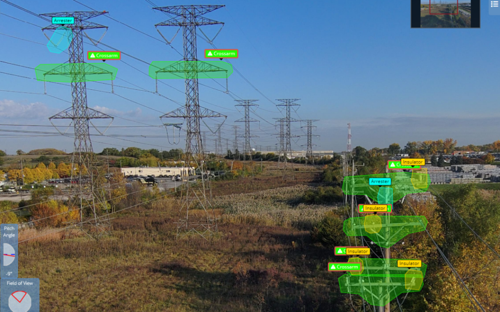
Drones equipped with high-resolution cameras and LiDAR sensors can inspect bridges, powerlines, wind turbines, pipelines, roofs, and large land areas in hours instead of days.
They collect detailed imagery, 3D models, and GIS-ready spatial data in a single flight, allowing teams to:
- Identify problems earlier
- Update GIS datasets instantly
- Reduce repeat site visits
- Make faster decisions based on accurate, real-time information
This means projects move forward quicker and asset managers can respond to issues before they escalate.
2. Reduce Costs Across the Entire Asset Lifecycle
Drone and LiDAR inspections dramatically cut the need for:
- Scaffolding
- Elevated work platforms (EWPs)
- Cranes
- Large on-site inspection crews
- Traffic control and site shutdowns
By reducing labour, equipment, travel, and downtime, companies can save thousands per inspection.
High-accuracy LiDAR and imagery also help detect issues early—like vegetation encroachment, structural movement, or erosion—avoiding expensive repairs, rebuilds, or environmental penalties later.
Better data means better planning, fewer surprises, and lower overall operational costs.
3. Keep Workers Safe
Safety is one of the biggest advantages of drones in asset management. Drones can reach:
- High-risk areas
- Confined spaces
- Hazardous terrain
- Heights that normally require fall-protection or elevated platforms
This keeps workers safely on the ground while still obtaining all the required data.
Industries such as construction, mining, energy, utilities, and emergency management use drones to:
- Reduce workplace accidents
- Minimise exposure to hazardous environments
- Provide real-time situational awareness during emergencies
LiDAR also improves safety planning by creating precise terrain models, helping teams understand the environment before stepping onto site.
4. Collect Better, Smarter Data with Drones and LiDAR
Modern drones give you fast, safe and extremely accurate data capture. When combined with LiDAR sensors and GIS mapping tools, you get information that is more detailed and reliable than traditional ground inspections. Using drone and LiDAR technology, asset managers and field teams can:
- Capture high-resolution imagery and 3D terrain models for precise measurement, planning and reporting.
- Generate accurate LiDAR point clouds that reveal ground levels, vegetation height, structural movement and changes that standard cameras can’t detect.
- Detect early signs of damage, corrosion, cracking or wear that are often missed during manual inspections.
- Monitor crop health, land condition and environmental change using multispectral imagery and LiDAR-based elevation data.
- Improve GIS datasets by collecting up-to-date spatial information that aligns with real-world conditions.
- Plan maintenance, repairs and future projects with confidence using accurate maps, contours, digital twins and elevation models.
Drone-based data collection is faster, safer and more cost-effective — giving you better insights, fewer site visits and smarter decision-making every day.
Drones are quiet, low-emission, and eco-friendly. Unlike heavy vehicles or helicopters, they don’t damage land or disturb wildlife. Drones can monitor sensitive areas while reducing environmental impact.
Real-World Drone Applications
At Drone Training Hub, we show businesses and professionals how drones are used in infrastructure and asset management across Australia:
- Bridges – Inspect hard-to-reach areas safely and frequently
- Powerlines & Towers – Detect hazards before they cause problems
- Buildings – Spot wear, damage, or maintenance needs quickly
- Land Surveys – Create accurate 3D maps for planning
- Environmental Monitoring – Track forest health, wildlife, and natural resources
- Construction – Monitor progress, reduce errors, and improve project efficiency
- Mining – Survey mines, monitor equipment, and track resources
- Public Safety – Assist in search and rescue or disaster response
Why Partner with Drone Training Hub in NT
At Drone Training Hub, we offer:
- RePL (Remote Pilot Licence) training
- Online drone courses
- Hands-on flight training
We help you use drones safely and efficiently, whether you’re:
- Starting a career in drones
- Upskilling for infrastructure and asset management
- Improving safety, efficiency, and data collection for your business
Drones are transforming the way Australians manage assets — and your journey starts here.
Contact Drone Training Hub today to learn how drones can revolutionize your infrastructure and asset management.